25 Years of SRTM
I noticed earlier last week that I just missed the 25th anniversary of the mission of the Shuttle Radar Topography Mission aboard STS-99. I’m not sure there has been a more important elevation data product that has been released to the public than SRTM.
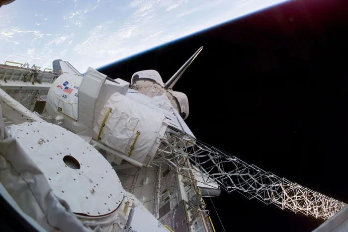
Given the uncertainty of funding for government programs in the new Trump administration, I’m not sure we’ll see another public 3D dataset in my time. Sure, there are private companies who collect much more detailed elevation data than SRTM, but none are as freely available as SRTM is (hopefully not was).

Spring Training 2025

This week is one of the best in baseball—the start of Spring Training, with players practice already underway. Sadly, it’s been a long time since the Giants last made a World Series run, and the Dodgers are as annoying as ever. But hey, the team is healthy, and baseball is always fun to watch!

Resurrecting Planet Geospatial
UPDATE: We have the domain working, you now just need to go to geofeeds.me and you’ll get the same results as below. The feed is at geofeeds.me/feed. You don’t need to update anything as the old urls will continue to work. Full speed ahead, make sure you reach out to Bill or myself if you want your blog, newsletter or other writing added.
A couple days ago, Bill Dollins reached out to me and had a crazy idea:
“Forget podcasting. We should resurrect planetgs”
It took me all of 10 seconds to respond, “Hell yes”. You can read the technical way it was brought back on Bill’s blog:
So, “Neptune” is born. The name is a nod to what Planet and Venus did/do, while the “N” planet hints at the Node underpinnings. Feel free to check it out. It’s about 50% me and about 50% Cursor. It’s not all the way baked, but good enough to release.
A lot has changed since I put Planet Geospatial to bed. It’s been 10 years, longer than Planet Geospatial was alive since the python script culled all those Blogger sites and spit out a HTML page and an RSS feed. The world has changed a couple times over, blogs which were falling out of style have started to come back, newsletters are everywhere and Twitter is a cesspool of junk.
Many of us had Planet Geospatial as our homepage (back when that was a thing) but feel free to grab the new temporary URL https://whale-app-k5eg5.ondigitalocean.app/view and the new feed https://whale-app-k5eg5.ondigitalocean.app/feed. We’re working at getting an easier domain set up because I let PlanetGS.com go many years ago and alas it has been taken.
I hope this helps many of you start blogging again, we need all the good content to survive the next few years.
Cable Management
One of the best parts of my iPhone 15 Pro is that it has a USB-C port on it. While I appreciate the lightning port, I have just grown so tired of having to manage so many different ports while traveling. Coupled with my iPad having USB-C and my Apple Watch having a USB-C charging cable, I went ahead and got myself an Anker 3 port USB-C charger (which has a USB-A for those times you need one) allowing me to plug in all my devices at night and just use ordinary USB-C cables.
It is all nice and clean, no longer do I have all different cables for each device. My Kindle is USB-C, my GoPro is USB-C, my battery backup is USB-C and of course my MacBook Pro. I have reduced the cables I travel with because I don’t need one for each device. I do travel with a USB-A to USB-C cable for those times where the airplane doesn’t have USB-C or in an airport or rental car but that tucks away nicely in my travel bag.

But then I just realized my AirPods Pro case is lightning.

Now I could buy a USB-C case for said AirPods, but I want to wait until September and see if there is anything new. So trusty old lightning cable goes back in the bad for now.
Update: I was asked how I charged my AirPods Pro last night, well you can use the Apple Watch charger. Works pretty well but its not a great solution long term.
Apple Maps Gets Topographical
 IMG_0054
GIS and Topo maps go hand in hand. From the classic Quad maps, to the National Geographic TOPO! product, to just basic Esri Topo map services, these topographic maps have been part of GIS since the beginning. Google Maps has had their “terrain” layer for a long time (though it seems to be fading out for some reason). Apple with the release of Watch OS 10 and the Ultra 2 added topographical maps to at least the watch ecosystem, but still required an iPhone to download the offline maps.
But yesterday Apple finally closed that hole and added topographical maps (including the trails feature) to iOS.
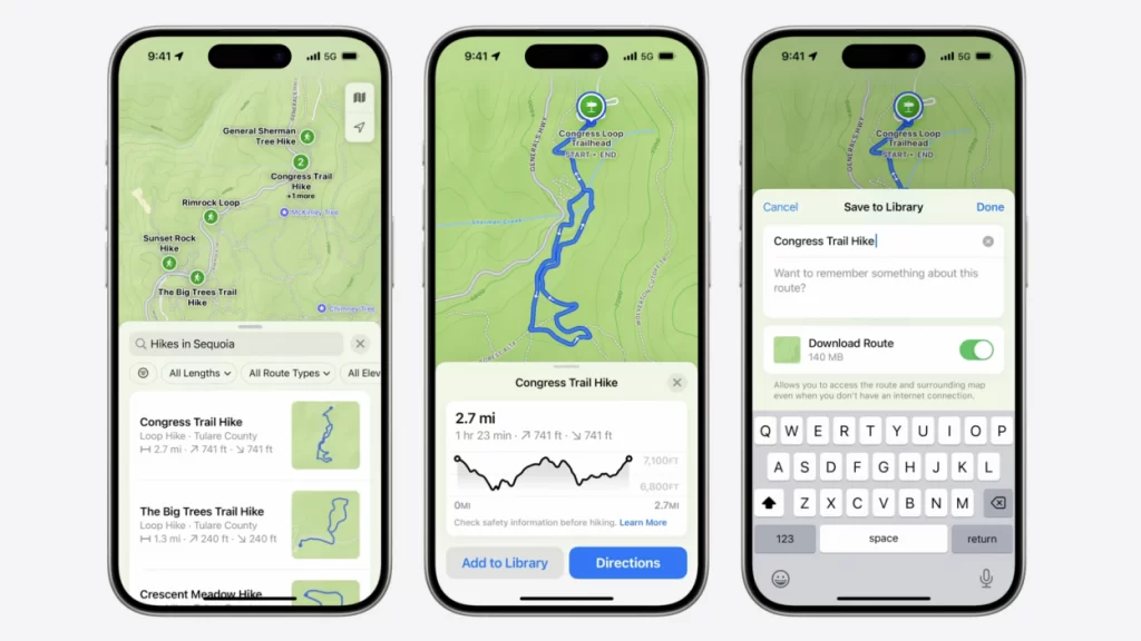
Now this is very user centric at this point. I expect to see these maps start appearing in apps that use MapKit but to what extent I’m not sure. I use onX Offroad quite a bit and suspect it will continue to use their own
ARC/INFO Manuals
 4A6FB86A-A903-4E07-AF1F-F9503A91189D
If there is one regret in my life, it is that I didn’t steal the ARC/INFO manual binders from one of the jobs I used to use ARC/INFO. I’ve had an eBay search going for years in hope that someone will give them up. I suspect every binder set that still exists will never be given up. It’s like owning a Picasso, you’d never sell it and ask your relatives to bury you with it.