Dapple, based on NASA World Wind
Chad Zimmerman pointed me to the new release of Dapple. I have to say, I am impressed. Here Geosoft took the open source code of NASA World Wind and modified it to better meet the needs of their users. I mean you could create your own Geographic Exploration System (GES) from scratch, but it makes much more business sense to take an existing open source GES and modify it for your own needs and in turn improve the whole open source project as a whole. One could work within the Google Earth universe, but that limits you as to what you can do on the client side. At some point ESRI will release ArcGIS Explorer and its API, but you still don’t have the kind of control over the project as you would with an open source GES such as NASA World Wind.
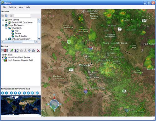
Well back to Dapple, the GUI seems definitely inspired by Google Earth which is a good thing to make users feel at home. No matter how pretty the NASA World Wind interface looks, I know that many are scared off from the non-Windows appearance that it gives off. I like how the table of contents of the map services is laid out, how easy it is to set transparency. I was creating pretty cool maps in no time. The improved WMS support gives you so much more ability to overlay map services that you can find on the Internet. I’d like to see some ArcIMS support as I’d still wager that ArcIMS dominates the web mapping field (at least in the areas I’m familiar with, I don’t get to Canada too much).
 dapple.jpg
I’m going to spend some time this week checking out Dapple and see what it can do. I’ll probably also take a look at SERVIR-VIZ which was posted in the comments of this blog. The only drawback I see is that it requires you to uninstall any previous SERVIR-VIZ (not a problem) or NASA World Wind (big problem) on your computer.