GeoJSON Ballparks as JSON
In a way it is good that Sean Gillies doesn’t follow me anymore. Because I can hear his voice in my head as I was trying to do something really stupid with the project. But Sheldon helps frame what I should be doing with what I was doing:
tables? what the? add , teams:[{name:"the name", otherprop: ...}, {name:...}] to each item in the ballparks array and get that relational db BS out of your brain
— Sheldon (@tooshel) April 2, 2021
Exactly! What the hell? Why was I trying to do something so stupid when the while point of this project is baseball ballparks in GeoJSON. Here is the problem in a nutshell and how I solved it. First off, let us simply the problem down to just one ballpark. Salt River Fields at Talking Stick is the Spring Training facility for both the Arizona Diamondbacks and the Colorado Rockies. Not only that, but there are Fall League and Rookie League teams playing there. Probably even more that I still haven’t researched. Anyway, GeoJSON Ballparks looks like this today when you just want to see that one stadium.
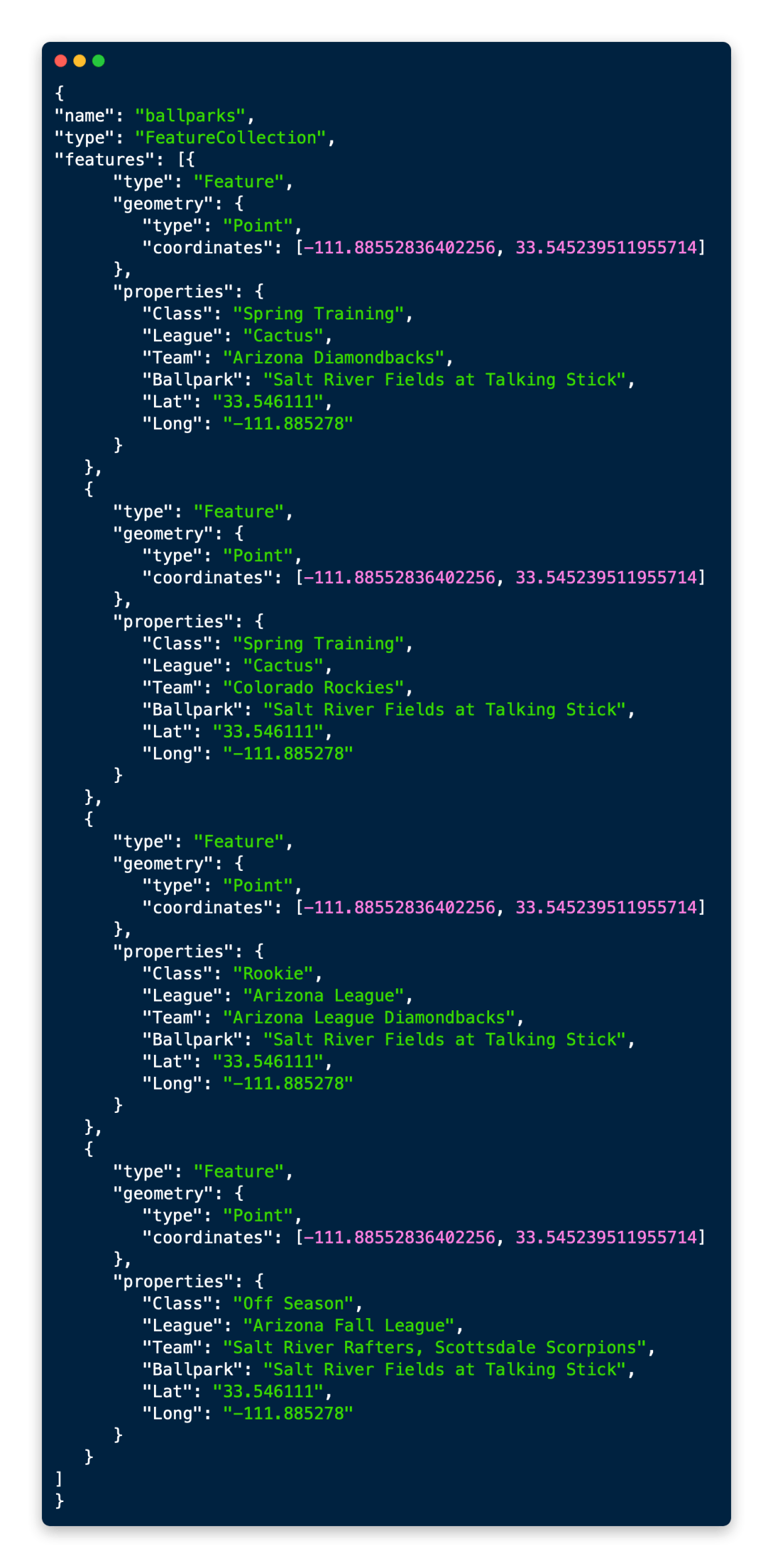
_Let’s just say I backed myself in this corner by starting by only having MLB ballparks, none of which at the time of the project were shared between teams.
It’s a mess right? Overlapping points, so many opportunities to screw up names. So my old school thought was just create a one-to-many relationship between the GeoJSON points and some external table. Madness! Seriously, what was I thinking? Sheldon is right, I should be doing a JSON array for the teams. Look how much nicer it all looks when I do this!
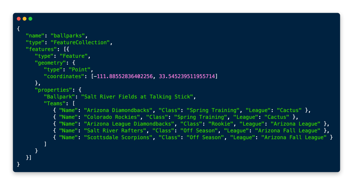
Look how nice that all is? So easy to read and it keeps the focus on the ballparks.
As I said in the earlier blog post.
The problem now is so many teams, especially in spring training, minor leagues and fall ball, share stadiums, that in GeoJSON-Ballparks, you end up with multiple dots on top of each other. No one-to-many relationship that should happen.”
The project had pivoted in a way I hadn’t anticipated back in 2014 and it was a sure a mess to maintain. So now I can focus on fixing the project with the Minor League Baseball realignment that went on this year and get an updated dataset in Github very soon.
One outcome of doing this nested array is that many GIS tools don’t understand how to display the data. Take a look at geojson.io:
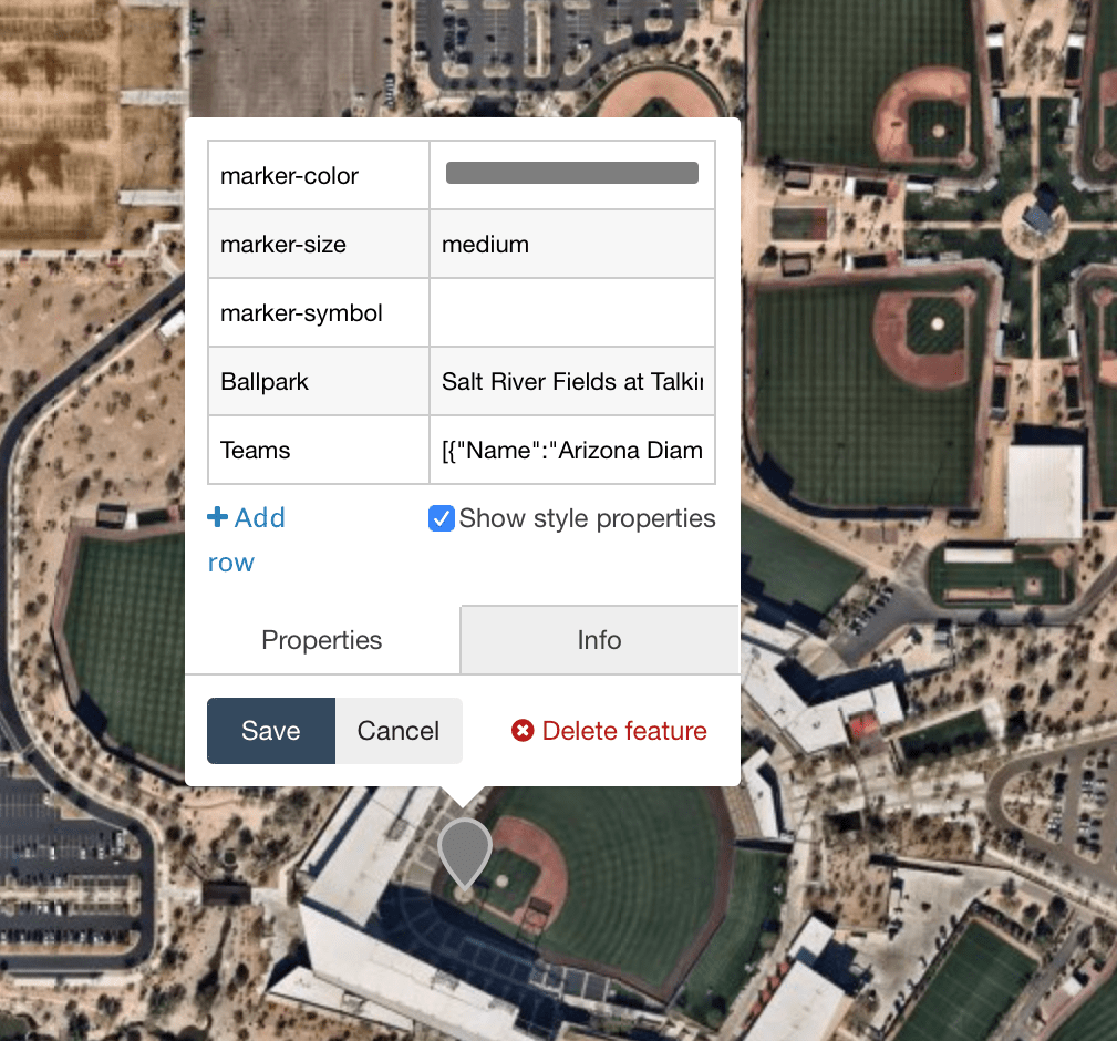
geojson.io compresses the array into one big JSON-formatted string. QGIS and Github do this also. It’s an issue that I’m willing to live with. Bill Dollins shared the GeoJSON spec with me to prove the way I’m doing is correct:
3.2.  Feature Object
   A Feature object represents a spatially bounded thing.  Every Feature
   object is a GeoJSON object no matter where it occurs in a GeoJSON
   text.
   o  A Feature object has a "type" member with the value
      "Feature".
   o  A Feature object has a member with the name
      "geometry".  The value of the geometry member SHALL
      be either a Geometry object as defined above or, in
      the case that the Feature is unlocated, a JSON
      null value.
   o  A Feature object has a member with the name
      "properties".  The value of the properties member is
      an object (any JSON object or a JSON null value).
ANY JSON OBJECT! So formatting the files this way is correct and the way it should be done. I’m going to push forward on cleaning up GeoJSON Ballparks and let the GIS tools try and catch up.