Make ArcGIS JavaScript Sample Viewer support more than WGS84
Users not wanting to use WGS84? Inconceivable!
 Inconceivable!
So you’ve downloaded the JavaScript Sample Viewer from ESRI and want to use it with your own services? Well make sure those basemap services are WGS84 because they won’t show up otherwise. You aren’t losing your mind when you see nothing in the viewer, just republish them as WGS84.
It would probably be a good idea for ESRI to update their docs to reflect this.
Update: Jithen, unlike me, wasn’t happy about having to use WGS84 and he has figured out a way to get it to work.
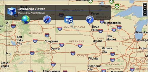
ESRI’s ArcGIS Server Sample JavaScript Viewer
ESRI has released a sample JavaScript viewer example with a developer’s guide to help you better understand how the JavaScript API works. It looks great (much like the Flex API) and does a darn good job having cross platform compatibility. As I said the Developer’s Guide is a great resource for those looking for an introduction to the JavaScript API, Dojo, Aptana Sudio, and what it takes to develop ArcGIS Server JavaScript applications.

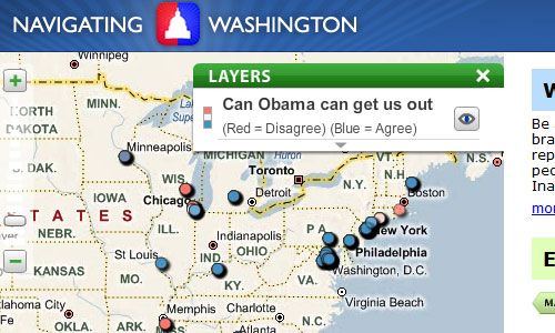
Navigating Washington
Just the other day we were wondering over the RSP Architects coffee machine about if GeoCommons would ever have an API. Rather than actually ask Sean if there was one in the works, it is of course easier to forget about the conversion and wait for Sean to blog about it himself. What I assume is one of the first GeoCommons API (this example is running on Amazon’s EC2) applications out there, Navigating Washington which allows real time poll mapping in your browser or even a Blackberry or iPhone (no Windows Mobile device because no one uses those anymore). I find the application very interesting and integration with mobile devices is a smart idea. I’m anxious to see what Sean has planned with the API and how we can use it.
What can’t maps do for you these days?
 What cant maps do for you these days?
Navigating Washington
Just the other day we were wondering over the RSP Architects coffee machine about if GeoCommons would ever have an API. Rather than actually ask Sean if there was one in the works, it is of course easier to forget about the conversion and wait for Sean to blog about it himself. What I assume is one of the first GeoCommons API (this example is running on Amazon’s EC2) applications out there, Navigating Washington which allows real time poll mapping in your browser or even a Blackberry or iPhone (no Windows Mobile device because no one uses those anymore). I find the application very interesting and integration with mobile devices is a smart idea. I’m anxious to see what Sean has planned with the API and how we can use it.
What can’t maps do for you these days?
What cant maps do for you these days?
MapQuest OpenAPI Alert!
Better get those MapQuest web mapping applications converted over soon!
The MapQuest OpenAPI product servers will go offline on?Saturday, January 31st, 2009. Applications not migrated off of the MapQuest OpenAPI product will?stop working?after this date.
Please don’t be that guy (or gal) who procrastinates and then winds up with the broken app in production.
