PHPGeoTiles for Google App Engine
You too can get your own tile cache running.
 You too can get your own tile cache running.
Looks like an interesting project. If TileCache has been trouble for you to get working right, PHPGeoTiles?might be something to keep an eye on. Already there is support for the ArcGIS REST API to Google App Engine.
Image used under Creative Commons from jereandreagan.
Arc2Earth 2.1 Update
Brian Flood comes up from the basement to give a glimpse of what has been happening in Arc2Earth land. Arc2Earth Cloud Services is looking really amazing and it is clear Brian has put much effort into it.
Arc2Earth 2.1 Update
Brian Flood comes up from the basement to give a glimpse of what has been happening in Arc2Earth land. Arc2Earth Cloud Services is looking really amazing and it is clear Brian has put much effort into it.
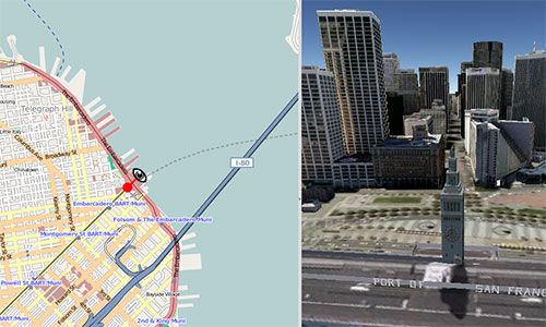
MapFish and Google Earth API
I’ve not seen much Google Earth API plugin use that makes me think it is anything more than a way to put 3D pushpins on a webpage, but the latest MapFish demo looks interesting.
There’s a full real-time interaction between MapFish and GE. Translation and rotation of special MapFish tool moves GE camera. Panning and camera tilting on GE side moves MapFish tool.
Just working a little with the JavaScript API and you can do some really neat things. Nothing unique about MapFish in this example, but if you haven’t been following MapFish lately, you need to put it on your radar.
MapFish on the left, Google Earth API on the right.
 MapFish on the left, Google Earth API on the right.
The Esri Enterprise License Agreement Enterprise License Agreement Is It Working
author: cageyjames comments: true date: 2009-01-06 07:00:00+00:00 layout: post slug: the-esri-enterprise-license-agreement-enterprise-license-agreement-is-it-working title: The ESRI Enterprise License Agreement Enterprise License Agreement - Is it working? — The ESRI salesman hits the road to sell the ELA
 The ESRI salesman hits the road to sell the ELA
Google is littered with press releases announcing customers signing up for ESRI Enterprise License Agreements. Most of these seem to be larger government organizations and corporations. But what about the Small Municipal and County Government Enterprise License Agreement Program we heard so much about last year? I’ve heard from a couple people that they’ve had difficulty with the ELA because they don’t “fit” into the program. As a ESRI Business Partner I am hopeful that this program would allow ESRI customers to get out of antiquated ArcIMS and ArcView 3.x applications and into the more modern ArcGIS 9.3 stuff. It would appear at least on the surface that it hasn’t been successful but maybe Google isn’t telling the whole story.
Anyone care to comment on the ELA program and its success/failures?