Google and GeoEye. Argle-bargle or Fufurah?
And I, for one, welcome our new geospatial overlords
 And I, for one, welcome our new geospatial overlords
I didn’t bother to blog about the Google and GeoEye announcement (Google launches satellite?? Are you kidding me Information Week?) from a couple weeks ago (or was it a couple days ago?) because I really didn’t see what was so newsworthy about it. It isn’t like this is the first announcement we’ve seen from Google and a satellite company. Plus Microsoft even went out and bought Vexcel (hmm didn’t blog about that acquisition either).
I just don’t care too much about these deals as they don’t affect me in any way. I still aquire my imagery the way I did before and I still use the free services the way I did before. The only thing this confirms to me is that you can’t make money from selling sattelite imagery on an open market, you need a sugar daddy to pay the bills. I guess that is what is the most telling thing out of this announcement, GeoEye’s and Digital Globe’s business models are broken.
Revising the United Countries of Baseball Map
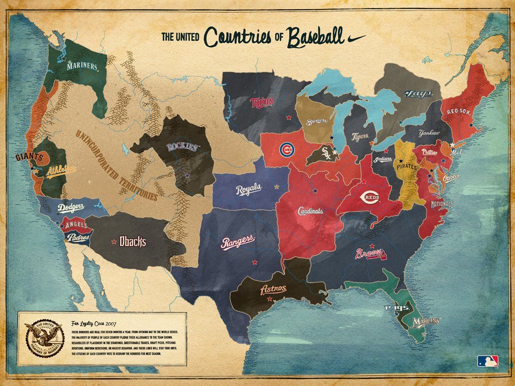
You might remember The United Countries of Baseball Map from last year.
 click for larger view
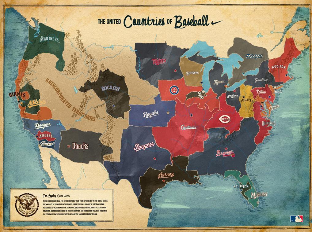
Any time you attempt to make a map such as this, you know people are going to find faults with it. Well Drew Silva took comments people made about the map on sites such as Deadspin and revised some of the boundaries of the map. I think the refinement really tightens up one of my favorite maps that I’ve ever seen. Check out the result below and compare with the CommonCensus Sports Map of MLB Team Fan Areas.
 click for larger view
Thanks to Dan for pointing this out to me. He also offered up the Major League Baseball blackout map. Also, no need to bring up the collapse of the Diamondbacks. I’m a fair-weather fan of them so it doesn’t really hurt me too much, especially since my team is surging in the standings (but unfortunately has nothing to play for).
Revising the United Countries of Baseball Map
You might remember The United Countries of Baseball Map from last year.
 click for larger view
Any time you attempt to make a map such as this, you know people are going to find faults with it. Well Drew Silva took comments people made about the map on sites such as Deadspin and revised some of the boundaries of the map. I think the refinement really tightens up one of my favorite maps that I’ve ever seen. Check out the result below and compare with the CommonCensus Sports Map of MLB Team Fan Areas.
 click for larger view
Thanks to Dan for pointing this out to me. He also offered up the Major League Baseball blackout map. Also, no need to bring up the collapse of the Diamondbacks. I’m a fair-weather fan of them so it doesn’t really hurt me too much, especially since my team is surging in the standings (but unfortunately has nothing to play for).
Netezza’s Spatial Extension to Data Warehouse Appliance
All Points Blog has the news that Netezza is set to release a “spatial extension” to their Data Warehouse Appliance. You may? not think you know much about Netezza, but know that their success keeps Larry Ellison up at night. There was some discussion on this blog about super fast geospatial analysis and what the target would be. I think basically Netezza is trying to solve problems that we currently can’t do with existing spatial databases in both scale and speed. I wouldn’t suspect seeing their product replacing Oracle Spatial or SQL Server, but for those who have the money to pay for the product this could help them answer questions they cannot do right now. For most of us, just sit back and marvel at what you could do if money was no option and know that in a year or two, much of this technology will be in your hands. Peter Batty says he’ll be blogging more about what exactly this means in the next week. Can’t wait to read it.
This is Star Trek quality spatial data analysis folks
Photo by paper or plastic?
Brian Timoney updates gulfimpact.com
Brian Timoney has updated his Gulf Coast Energy Impact website with Hurricane Ike information. It also looks like Brian has gotten a sponsor for his work, IHS (who many might better know as the publisher of this).
Ike’s impacts on Gulf Coast energy
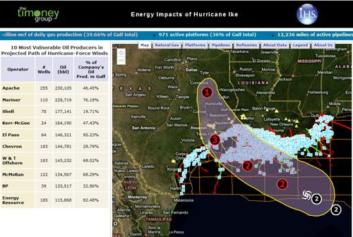 Ikes impacts on gulf coast energy