Using SVG to create interactive maps on the Apple iPhone
So you can’t have Silverlight, Java or Flash to develop interactive mapping on the iPhone and have to “resort” to using JavaScript. Well maybe not, could SVG be the way forward to creating mapping websites on the iPhone?? My 2G iPhone seems to support SVG fairly well, but many SVG sites aren’t optimized for the iPhone. Take ESRI’s abandoned (?) SVG Viewer:
ESRI’s ArcWeb SVG Viewer
 ESRIs ArcWeb SVG Viewer
It loads and you can turn on and off the “widgets” with ease. But navigating it was impossible. I know zero about developing with SVG so I suppose someone else will have to comment on if it is possible to create iPhone compatible navigation for SVG apps. Heck if ESRI were to make a ArcGIS Server SVG API compatible for the iPhone, every ArcGIS Server implementation would be viewable on the iPhone.
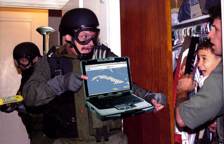
GIS on the law enforcement front lines
GIS Analysts are usually in the back room performing support rolls with most law enforcement operations, but recently a GIS Analyst was part of a marijuana eradication raid in California.
A GIS specialist went in with the raid teams for the first time in NPS history to perform an immediate on the ground evaluation of the impacts to the natural resource during the raid.
Just think how much better some law enforcement situations might have gone if GIS had been part of the raid.
 GIS on the front lines of law enforcement
Redwood National and State Parks (CA) Major Interagency Raid Conducted On Marijuana Plantation_
On September 10th, Redwood National and State Parks conducted a marijuana eradication raid, utilizing an interagency anti-drug task force. The focus of the effort was a marijuana plantation in Redwood Creek that contained 9,564 plants and covered approximately five acres on steep terrain. This marijuana site is within six miles of the world’s tallest tree in a park that is also a World Heritage Site and International Biosphere Reserve. Rangers detained five Mexican nationals for questioning about a mile from the marijuana growing operation. Three of them had prior deportations and were transferred to United States Immigration and Customs Enforcement (ICE). One who is on felony probation for marijuana was held on that violation and will be deported later. The fifth was charged with providing false information to an officer. A GIS specialist went in with the raid teams for the first time in NPS history to perform an immediate on the ground evaluation of the impacts to the natural resource during the raid. This documentation will be very beneficial for the restoration process. Significant resource damage has resulted from this illegal activity and an initial cleanup operation using California National Guard soldiers and helicopter is planned for October. This raid included almost 60 law enforcement and support staff. The National Park Service wishes to acknowledge and thank the support provided by Humboldt County Sheriff Office, Campaign Against Marijuana Planting (CAMP), North State Marijuana Investigation Team, California Department of Justice, California Fish and Game, California Bureau of Narcotics Enforcement, Green Diamond Resources Company, United States Coast Guard, Drug Enforcement Agency (DEA), Federal Bureau of Investigation (FBI), United States Marshall Service, California State Park Rangers, National Park Service SETT II team and ISB Pacific West special agents.
[Submitted by Rick Nolan, Chief of Interpretation and Education]
Yahoo! Pipes or Microsoft Popfly Replacing ESRI’s Model Builder?
Vish wonders aloud if we are close to using online tools to replace ESRI’s venerable Model Builder.
Why can’t you get RESTful with ESRI’s Web Services?
 Why cant you get RESTful with ESRIs Web Services?
Yahoo! Pipes or Microsoft Popfly Replacing ESRI’s Model Builder?
Vish wonders aloud if we are close to using online tools to replace ESRI’s venerable Model Builder.
Why can’t you get RESTful with ESRI’s Web Services?
 Why cant you get RESTful with ESRIs Web Services?
Google and GeoEye. Argle-bargle or Fufurah?
And I, for one, welcome our new geospatial overlords
 And I, for one, welcome our new geospatial overlords
I didn’t bother to blog about the Google and GeoEye announcement (Google launches satellite?? Are you kidding me Information Week?) from a couple weeks ago (or was it a couple days ago?) because I really didn’t see what was so newsworthy about it. It isn’t like this is the first announcement we’ve seen from Google and a satellite company. Plus Microsoft even went out and bought Vexcel (hmm didn’t blog about that acquisition either).
I just don’t care too much about these deals as they don’t affect me in any way. I still aquire my imagery the way I did before and I still use the free services the way I did before. The only thing this confirms to me is that you can’t make money from selling sattelite imagery on an open market, you need a sugar daddy to pay the bills. I guess that is what is the most telling thing out of this announcement, GeoEye’s and Digital Globe’s business models are broken.